GHGSAT & Sentinel-5P TROPOMI Satellites Detect Giant Methane Emission From Ethiopia's Mount Fentale Volcano
Montreal, Canada (February 7, 2025) -- GHGSAT, the world leader in emissions monitoring, has detected a substantial methane emission from Mount Fentale, an active volcano in Ethiopia.
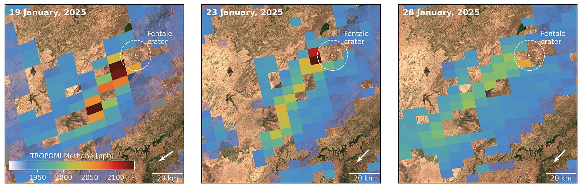
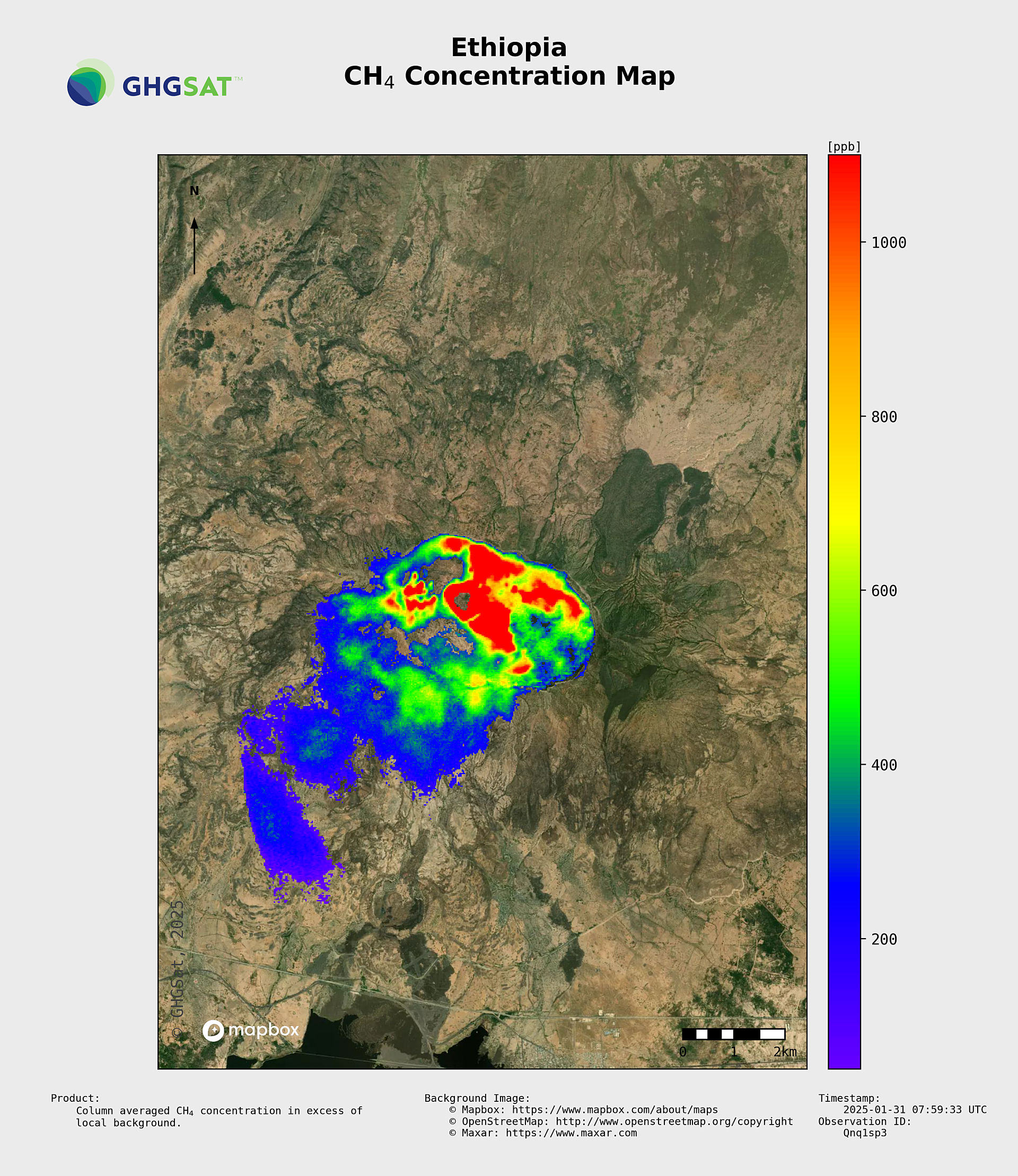
The emission, estimated at 58 metric tonnes per hour (or roughly 1400 metric tonnes/day), was observed on January 31 through a "tip and cue" approach between Europe’s Copernicus program’s Sentinel-5P TROPOMI satellite instrument and GHGSAT’s satellite constellation, coordinated by SRON Netherlands Institute for Space Research and GHGSAT.
SRON is contracted to provide the detection of large methane plumes from TROPOMI data to the European Copernicus Atmospheric Monitoring Service (CAMS), supporting CAMS’ mission to provide consistent and quality-controlled information related to air pollution and health, solar energy, greenhouse gases, and climate forcing everywhere in the world.
After SRON detected a “hot spot” with an unusually high concentration of methane in the atmosphere in repeated observations by TROPOMI near the Fentale volcano, GHGSAT zoomed in with its high-resolution sensors for a targeted follow-up measurement that pinpointed the Mount Fentale crater as the source of the emission.
Recent weeks have seen heightened seismic activity around Mount Fentale (also spelled Fantale), a prominent stratovolcano located in the Ethiopian Rift Valley. Local geological monitoring agencies have reported multiple earthquakes and signs of potential magma movement beneath the surface. Satellite measurements by the UK Centre for the Observation and Modelling of Earthquakes, Volcanoes, and Tectonics (COMET) have revealed that a large underground crack in the earth’s crust, or a “dike,” has also emerged, stretching a distance of approximately 50 kilometers from Mount Fentale northeast towards the Dofen volcano. More than 80,000 people living in the region have been preemptively evacuated due to concerns about possible volcanic activity.
Combined with the geological activity in the area, this methane detection can provide clues about what is happening below the Earth’s surface. Prof. John Stix, a scientist with McGill University, assessed that over the past several weeks, magma under the Fentale volcano may have propagated to the northeast through these cracks in the earth’s crust, explaining the earthquakes in the region. As the magma drained from the reservoir beneath Mount Fentale, the ground surface sank, deflating.
These types of magma movements typically have associated carbon dioxide and/or sulfur dioxide emissions from the volcano’s reservoir. Spotting such a large methane emission from a volcanic site is rare. Its presence points the scientific community to a different possible scenario: that of a shallow, isolated geothermal or hydrothermal reservoir underneath Fentale’s crater. Geothermal reservoirs can have significant amounts of methane and may be disconnected from the deeper magma reservoir. With the recent earthquakes, pathways between the geothermal reservoir and the surface, such as cracks or faults, may have developed to allow the methane to escape.
“It will be very interesting to see if TROPOMI detects sulfur dioxide at Fentale in the coming weeks and months, which may signify magma degassing,” said Prof. Stix.
Methane is a potent greenhouse gas with a warming potential over 80 times greater than carbon dioxide over a 20-year period. While industrial sources comprise the bulk of methane emissions globally, understanding emissions from natural phenomena—including their occurrence and scale—is essential for accurate climate modeling.
“We automatically scan the global TROPOMI observations to find large emission plumes as part of our European CAMS service. This was a very surprising and exciting finding; we have never detected such large methane emissions from a volcanic area before,” said Ilse Aben, Senior Scientist at SRON and TROPOMI co-Principal Investigator.
“This is an excellent example of how the tip-and-cue approach works, combining information from operational satellites with more detailed zoom-in information from companies like GHGSat. GHGSat recently joined the Copernicus Contributing Missions programme, which will allow even more collaboration between them and CAMS,” said Richard Engelen, Deputy Director of CAMS.
“This detection underscores the power of Earth observation to unearth new insights about age-old phenomena,” said Stephane Germain, CEO of GHGSAT. “Combining the regional-level view of TROPOMI with GHGSAT’s ability to pinpoint emission sources, we can detect and quantify changes in greenhouse gases all the way from low-Earth orbit—even from areas that might be inaccessible, like an active volcano site.”
###
About GHGSat
GHGSat uses its own satellites and aircraft sensors to measure greenhouse gas emissions directly from industrial sites, providing actionable insights to businesses, governments, and regulators. With proprietary remote-sensing and patented technology, GHGSat enables strategic decision-making through monitoring and analytics services, with better accuracy, more frequently, and at a fraction of the cost of other technologies. GHGSat’s mission is to become the global reference for remote sensing of greenhouse gas (GHG), air quality gas, and other trace gas emissions from any source in the world. Learn more about GHGSat at ghgsat.com.
About SRON
SRON is the Dutch national expertise institute for space research, as part of the Dutch Research Council (NWO). SRON is the co-PI institute for the TROPOMI instrument aboard ESA Sentinel-5 Precursor. TROPOMI is a partnership between Airbus Defence and Space Netherlands, KNMI, SRON, and TNO, commissioned by NSO and ESA. SRON provides the detection of large methane plumes to the European Copernicus Atmospheric Monitoring Service (CAMS). Sentinel-5P and Sentinel-2 are part of the EU Copernicus program.
About CAMS
The Copernicus Atmosphere Monitoring Service (CAMS) is one of six services that form Copernicus, the European Union's Earth observation programme which looks at our planet and its environment for the ultimate benefit of all European citizens. Copernicus offers information services based on satellite Earth observation, in situ (non-satellite) data, and modeling. CAMS is implemented by the European Centre for Medium-Range Weather Forecasts (ECMWF) on behalf of the European Commission. ECMWF is an independent intergovernmental organisation supported by 35 states. It is both a research institute and a 24/7 operational service, producing and disseminating numerical weather predictions to its member states.
Media Contact:
Alison Boyer
First Volcanic Emission Detected by Satellite
GHGSAT & Sentinel-5P TROPOMI Satellites Detect Giant Methane Emission from Ethiopia’s Mount Fentale Volcano
By GHGSAT


Comments
Post a Comment